
Information
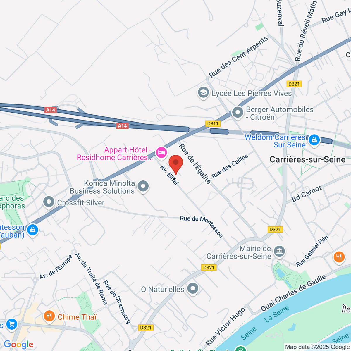
1 Av. Eiffel, 78420 Carrières-sur-Seine, France
+33 1 80 88 45 01
-
-

Overview
- Summary
- SBG Systems is a French company that designs, manufactures, and sells miniature to high-end Inertial Navigation Systems, Inertial Sensors, IMU, AHRS, and MRU. It is a leading supplier of high-precision navigation and motion sensing solutions based on MEMS technology and advanced data fusion algorithms. The company focuses on developing innovative, compact, and cost-effective motion sensors, serving customers in over 70 countries.SBG Systems is a French company that designs, manufactures, and sells miniature to high-end Inertial Navigation Systems, Inertial Sensors, IMU, AHRS, and MRU. It is a leading supplier of high-precision navigation and motion sensing solutions based on MEMS technology and advanced data fusion algorithms. The company focuses on developing innovative, compact, and cost-effective motion sensors, serving customers in over 70 countries.
- Key Products/Technologies
- Inertial Measurement Units (IMU): The Pulse-40 IMU is a tactical-grade 6DoF IMU suitable for high-performance motion monitoring. The Ellipse Micro IMU offers the highest accuracy in a miniature package, utilized for high-performance motion monitoring.Inertial Measurement Units (IMU): The Pulse-40 IMU is a tactical-grade 6DoF IMU suitable for high-performance motion monitoring. The Ellipse Micro IMU offers the highest accuracy in a miniature package, utilized for high-performance motion monitoring.
- Attitude and Heading Reference Systems (AHRS) / Motion Reference Units (MRU): The Ellipse Micro AHRS provides accurate orientation in dynamic conditions. The Apogee-A is a high-performance orientation and heave data solution based on robust and cost-effective MEMS technology, featuring an IP68-rated rugged enclosure.Attitude and Heading Reference Systems (AHRS) / Motion Reference Units (MRU): The Ellipse Micro AHRS provides accurate orientation in dynamic conditions. The Apogee-A is a high-performance orientation and heave data solution based on robust and cost-effective MEMS technology, featuring an IP68-rated rugged enclosure.
- Inertial Navigation Systems (INS) with embedded GNSS (INS/GNSS): The Ellipse Series is a line of miniature, high-performance MEMS-based INS/GNSS products. Ellipse-N offers compact, high-performance single-antenna GNSS with precise centimeter-level positioning. Ellipse-E provides precise navigation by integrating with external GNSS and sensors, and Ellipse-D is the smallest INS with dual-antenna GNSS, offering multi-band and centimeter-level accuracy.Inertial Navigation Systems (INS) with embedded GNSS (INS/GNSS): The Ellipse Series is a line of miniature, high-performance MEMS-based INS/GNSS products. Ellipse-N offers compact, high-performance single-antenna GNSS with precise centimeter-level positioning. Ellipse-E provides precise navigation by integrating with external GNSS and sensors, and Ellipse-D is the smallest INS with dual-antenna GNSS, offering multi-band and centimeter-level accuracy.
- The Apogee Series comprises high-performance and versatile MEMS inertial navigation systems. Apogee-E connects to any survey-grade GNSS receiver for navigation, providing precise orientation and position data with very low noise gyroscopes and low latency. Apogee-D embeds a dual-antenna, triple-frequency survey-grade GNSS receiver, ready for RTK and PPP.The Apogee Series comprises high-performance and versatile MEMS inertial navigation systems. Apogee-E connects to any survey-grade GNSS receiver for navigation, providing precise orientation and position data with very low noise gyroscopes and low latency. Apogee-D embeds a dual-antenna, triple-frequency survey-grade GNSS receiver, ready for RTK and PPP.
- The Quanta Series offers high-performance GNSS-aided INS with the smallest form factor for direct georeferencing in UAV and land-based surveying solutions. Quanta Plus combines a tactical IMU with a high-performance GNSS receiver for reliable position and attitude even in harsh GNSS environments.The Quanta Series offers high-performance GNSS-aided INS with the smallest form factor for direct georeferencing in UAV and land-based surveying solutions. Quanta Plus combines a tactical IMU with a high-performance GNSS receiver for reliable position and attitude even in harsh GNSS environments.
- Stellar-40 is a tactical-grade resilient INS, engineered for mission-critical operations in the harshest environments, delivering precise and reliable navigation even in the presence of jamming, spoofing, or GNSS outages.Stellar-40 is a tactical-grade resilient INS, engineered for mission-critical operations in the harshest environments, delivering precise and reliable navigation even in the presence of jamming, spoofing, or GNSS outages.
- Qinertia Post-Processing Software: A GNSS+INS post-processing software designed to deliver centimeter-level positioning and highly accurate trajectories. It features multi-constellation & multi-frequency GNSS, flexible processing modes, multi-sensor aiding, and image geo-tagging capabilities.Qinertia Post-Processing Software: A GNSS+INS post-processing software designed to deliver centimeter-level positioning and highly accurate trajectories. It features multi-constellation & multi-frequency GNSS, flexible processing modes, multi-sensor aiding, and image geo-tagging capabilities.
- SAF2Nav Resilient Navigation Stack: A new standard for resilient navigation, fusing multiple data sources to deliver continuous, trustworthy positioning even in the most hostile jamming and spoofing environments, addressing the unreliability of traditional GNSS.SAF2Nav Resilient Navigation Stack: A new standard for resilient navigation, fusing multiple data sources to deliver continuous, trustworthy positioning even in the most hostile jamming and spoofing environments, addressing the unreliability of traditional GNSS.
- Core Advantages
- High-Performance MEMS-based Sensor Technology: The ability to provide compact, cost-effective, yet high-precision inertial sensors by leveraging MEMS technology.High-Performance MEMS-based Sensor Technology: The ability to provide compact, cost-effective, yet high-precision inertial sensors by leveraging MEMS technology.
- Proprietary Advanced Algorithms and Firmware: Combining strict sensor selection, advanced calibration techniques, and powerful embedded algorithms to maintain very high performance at every level. Continuous algorithm improvements include latest-generation navigation algorithms, enhanced attitude accuracy, improved heave accuracy, and heightened immunity to magnetic disturbances.Proprietary Advanced Algorithms and Firmware: Combining strict sensor selection, advanced calibration techniques, and powerful embedded algorithms to maintain very high performance at every level. Continuous algorithm improvements include latest-generation navigation algorithms, enhanced attitude accuracy, improved heave accuracy, and heightened immunity to magnetic disturbances.
- Diverse Product Portfolio and Customized Solutions: Offering a comprehensive range of inertial sensors including IMUs, AHRS, and INS/GNSS, along with OEM sensor solutions, tailored to meet diverse industry and application requirements.Diverse Product Portfolio and Customized Solutions: Offering a comprehensive range of inertial sensors including IMUs, AHRS, and INS/GNSS, along with OEM sensor solutions, tailored to meet diverse industry and application requirements.
- Robustness and Resilience in Challenging GNSS Environments: Expertise in providing accurate and reliable position and attitude data even in environments with weak or obstructed GNSS signals, such as urban canyons, tunnels, forests, and jamming/spoofing scenarios. Development of resilient navigation stacks like SAF2Nav.Robustness and Resilience in Challenging GNSS Environments: Expertise in providing accurate and reliable position and attitude data even in environments with weak or obstructed GNSS signals, such as urban canyons, tunnels, forests, and jamming/spoofing scenarios. Development of resilient navigation stacks like SAF2Nav.
- Integrated Software Solutions: Maximizing sensor performance through powerful post-processing software like Qinertia, and providing user-friendly tools for setup and data analysis.Integrated Software Solutions: Maximizing sensor performance through powerful post-processing software like Qinertia, and providing user-friendly tools for setup and data analysis.
- Global Market Presence and Customer Support: Serving customers in over 70 countries, with efforts to expand globally including establishing a subsidiary in the United States, and providing technical support and a 2-year warranty.Global Market Presence and Customer Support: Serving customers in over 70 countries, with efforts to expand globally including establishing a subsidiary in the United States, and providing technical support and a 2-year warranty.
- Target Industries
- Geospatial: High-precision mapping, surveying, and positioning tasks, including hydrography, mobile mapping, UAV LiDAR & photogrammetry, indoor mapping, instrumented buoys, and aerial surveying.Geospatial: High-precision mapping, surveying, and positioning tasks, including hydrography, mobile mapping, UAV LiDAR & photogrammetry, indoor mapping, instrumented buoys, and aerial surveying.
- Vehicles: Autonomous vehicle technology, robotics, drones, construction machines, precision farming, and autonomous underwater vehicles.Vehicles: Autonomous vehicle technology, robotics, drones, construction machines, precision farming, and autonomous underwater vehicles.
- Defense: Missile guidance, unmanned aerial systems, naval stabilization, ground-based vehicle navigation, precision guided munitions, and loitering munitions.Defense: Missile guidance, unmanned aerial systems, naval stabilization, ground-based vehicle navigation, precision guided munitions, and loitering munitions.
- Marine: Hydrography, marine surveying, unmanned marine vessels (UMV), autonomous underwater vehicles (AUV), unmanned surface vessels (USV), offshore platform stabilization, SONAR data georeferencing, ship motion monitoring, buoy positioning, oceanographic studies, offshore energy, and offshore wind farm construction.Marine: Hydrography, marine surveying, unmanned marine vessels (UMV), autonomous underwater vehicles (AUV), unmanned surface vessels (USV), offshore platform stabilization, SONAR data georeferencing, ship motion monitoring, buoy positioning, oceanographic studies, offshore energy, and offshore wind farm construction.
- Aerospace: Unmanned systems and aerial surveying.Aerospace: Unmanned systems and aerial surveying.
- Industrial Automation: Industrial robots and automation systems.Industrial Automation: Industrial robots and automation systems.
- Research: Various industrial and technological research projects.Research: Various industrial and technological research projects.
- Major Markets
- Singapore, Japan, South Korea, ChinaSingapore, Japan, South Korea, China
- France, Germany, Spain, Italy, Poland, United KingdomFrance, Germany, Spain, Italy, Poland, United Kingdom
- United StatesUnited States
- BrazilBrazil
- Certifications/Patents
- ISO 9001 Certification: Adherence to international standards for quality management systems.ISO 9001 Certification: Adherence to international standards for quality management systems.
- Innovation Trophy at the MOCI Trophées: Awarded for its long-standing commitment to advanced inertial navigation technologies and strong international footprint.Innovation Trophy at the MOCI Trophées: Awarded for its long-standing commitment to advanced inertial navigation technologies and strong international footprint.
- ITAR Free Products: Certain products, such as the Apogee Marine Series, are free from International Traffic in Arms Regulations (ITAR).ITAR Free Products: Certain products, such as the Apogee Marine Series, are free from International Traffic in Arms Regulations (ITAR).
- Technological Strengths: Expertise in designing and manufacturing compact, cost-effective, high-performance sensors based on MEMS technology. Optimization of performance through strict sensor selection, advanced calibration techniques, and powerful embedded algorithms. Dynamic calibration over the full temperature range and built-in vibration monitoring features. Development of resilient navigation stacks like SAF2Nav.Technological Strengths: Expertise in designing and manufacturing compact, cost-effective, high-performance sensors based on MEMS technology. Optimization of performance through strict sensor selection, advanced calibration techniques, and powerful embedded algorithms. Dynamic calibration over the full temperature range and built-in vibration monitoring features. Development of resilient navigation stacks like SAF2Nav.
Introduction
Location
1 Av. Eiffel, 78420 Carrières-sur-Seine, France
클릭하여 위치 살펴보기